Create Terrain
The Create Terrain tool is available only when working in a three-dimensional model. Use this tool to create a digital terrain model to represent a stratum found in the boreholes.
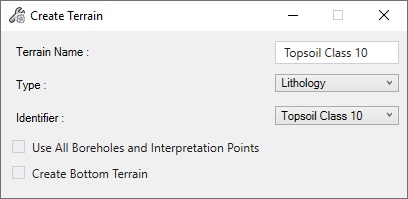
To create a terrain object, the following properties need to be defined:
- Terrain Name – User defined. The name of the terrain to be created.
- Type – Comes from the database. Which property type will be used to create the terrain.
- Identifier – Comes from the database. Which property will be used to create the terrain.
- Use all Boreholes and Interpretation Points – When checked, automatically selects all loaded boreholes and interpretation points (if any) to create the terrain.
- Create Bottom Terrain – When checked, the terrain will be created using the Bottom Depth of a layer instead of the Depth.